wayman
Engineer
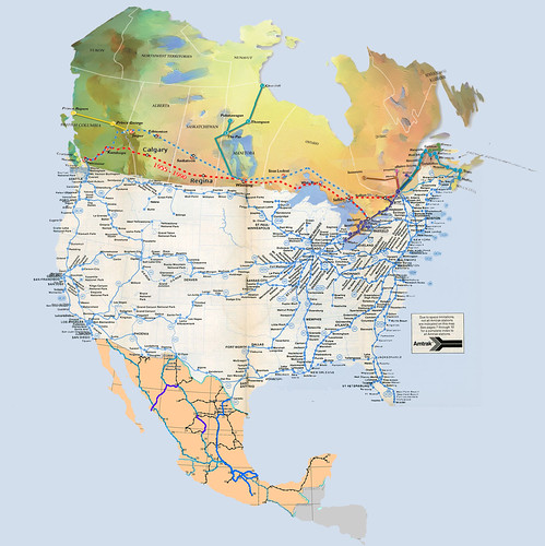
The Amtrak timetable's system map used to include VIA, but hasn't for a year or few now. So I put one together, adjusting the scales and perspectives of Amtrak and VIA maps to fit them together.
Click on the map to go to the full-size version with readable city names:
You really, really don't want to know how many different Photoshop layers that Canadian map got divided into!
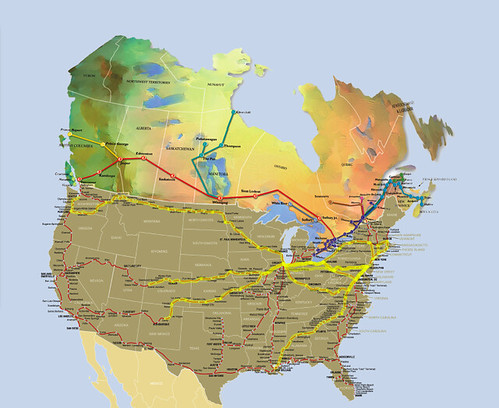
At some point I'll start looking at interconnectivity points a bit more. Obviously, Montreal, Toronto, and Vancouver are direct connections. With short non-train (but possibly not pub-trans-able) connections, Detroit/Windsor, Port Huron/Sarnia, and St.Albans/Montreal. With creativity, Portland/Halifax (CAT Ferry), Bellingham/Victoria (ferry). With creativity and tremendous dedication (and considerable expense), Bellingham-to-Skagway-to-PrinceRupert (ferry, ferry; I can't find a single-trip Amtrak-to-PrinceRupert connecting ferry). Things I have no idea about yet but which look like there might be a bus or something, GrandForks/Winnipeg.
If I get really ambitious, I'll add additional highly-useful non-train connections between routes (like Amtrak Thruway bus routes and non-Thruway buses providing valuable links), notable commuter rail lines, other rail lines which connect to Amtrak/VIA (Santa Fe Southern, Grand Canyon), and lengthy notable other rail lines (Cumbres & Toltec, Rocky Mountaineer, etc). Also, Alaska (Alaskan RR, Skagway). ("If I get really ambitious" probably means "if I get bored next week" )
)
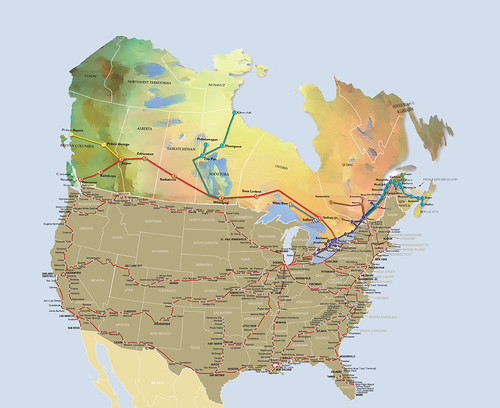
Meanwhile, my main reason for doing this was so I could have a full North American map to color in to record my progress (using more Photoshop layers for the highlighting):
If you want to do likewise, just download the full-size system map, open it up in Photoshop, and use a roughly 60% opacity 15-pixel brush to highlight routes you've traveled I'm using separate layers for each route, which means that when multiple routes traverse the same track section (like the NEC/Crescent/Cardinal, the CL/LSL, etc) the highlighting gets darker. For the one route I've taken that's no longer on the Amtrak map (Three Rivers to Chicago) I just eyeballed it.
(No, after some consideration I don't think I'll bother adding Mexico just to include the Copper Canyon line. Alas, RIP Mexican passenger railroads.)
Click on the map to go to the full-size version with readable city names:
You really, really don't want to know how many different Photoshop layers that Canadian map got divided into!
At some point I'll start looking at interconnectivity points a bit more. Obviously, Montreal, Toronto, and Vancouver are direct connections. With short non-train (but possibly not pub-trans-able) connections, Detroit/Windsor, Port Huron/Sarnia, and St.Albans/Montreal. With creativity, Portland/Halifax (CAT Ferry), Bellingham/Victoria (ferry). With creativity and tremendous dedication (and considerable expense), Bellingham-to-Skagway-to-PrinceRupert (ferry, ferry; I can't find a single-trip Amtrak-to-PrinceRupert connecting ferry). Things I have no idea about yet but which look like there might be a bus or something, GrandForks/Winnipeg.
If I get really ambitious, I'll add additional highly-useful non-train connections between routes (like Amtrak Thruway bus routes and non-Thruway buses providing valuable links), notable commuter rail lines, other rail lines which connect to Amtrak/VIA (Santa Fe Southern, Grand Canyon), and lengthy notable other rail lines (Cumbres & Toltec, Rocky Mountaineer, etc). Also, Alaska (Alaskan RR, Skagway). ("If I get really ambitious" probably means "if I get bored next week"
)Meanwhile, my main reason for doing this was so I could have a full North American map to color in to record my progress (using more Photoshop layers for the highlighting):
If you want to do likewise, just download the full-size system map, open it up in Photoshop, and use a roughly 60% opacity 15-pixel brush to highlight routes you've traveled
I'm using separate layers for each route, which means that when multiple routes traverse the same track section (like the NEC/Crescent/Cardinal, the CL/LSL, etc) the highlighting gets darker. For the one route I've taken that's no longer on the Amtrak map (Three Rivers to Chicago) I just eyeballed it.(No, after some consideration I don't think I'll bother adding Mexico just to include the Copper Canyon line. Alas, RIP Mexican passenger railroads.)
Last edited by a moderator: