Progress on Kashmir Rail Link

Amtrak Unlimited Discussion Forum

Help Support Amtrak Unlimited Discussion Forum:

This site may earn a commission from merchant affiliate links, including eBay, Amazon, and others.
JIS: Why is it called an asymmetrical bridge? It seem to have an equal number of cables on each side of the central pillar? Admittedly I was not able to count the cables in these images but they looked equal.
I think it has to do with the fact that the cable supported decks on the two sides of the supporting pillar are of different length.
 
Looks like one of the three mentioned extensions of the Kashmir Rail Link is moving towards reality. Tenders have been called for the 50km extension from the current Norther terminus at Baramulla to Uri near the Line of Control between India and Pakistan.

https://www.greaterkashmir.com/kashmir/50-km-baramulla-uri-railway-line-in-offing
The other extension that has been sanctioned is the 39km Baramulla to Kupwara extension, yet another to the vicinity of the LoC further North. The third extension is a long range plan to add a branch up Zoji La Pass to Kargil and thence to Leh.
 
Just a quick update. Recently I saw a set of photos in an article in local language. They show that laying of track on the bridge is complete. Electrification poles are in place, getting ready to receive catenary. It is likely that the entire project will be ready for initial service late in 2024 or early 2025, even thugh they officially say mid-2024.
 
I was trying to trace the route on Google Terrain Map, and discovered that most of it is in tunnels. It comes out of tunnels for a short distance at each station. But the few places that it is visible, augmented by available YouTube videos more recent than Google map updates, clearly tracks are in place and at least electrification poles are in place. Catenary installation is in progress but there is quite a ways to go before that is completed.
 
Last edited:
Here is a very informative article about the Katra - Banihal last phase of the Kashmir Rail Link. Unfortunately one has to have a subscription to Railway Gazette International, but as it is the best and most impartial article devoid of any nationalist chest thumping that I could find, I thought I will post it with the subscription warning anyway...

https://www.railwaygazette.com/in-depth/india-kashmir-link-nears-completion/64406.article
Now it looks highly likely that the entire project will be completed and service inaugurate sometime in 2024. The more optimistic think it will be by March but I am not one those, given what I know about the state of work on Tunnel T1. Later in the year seems more likely to me.
 
Last edited:
First MEMU trial run on the 50 km segment at the Northern end between Banihal and Sumbar of the 111 km segment under construction between Banihal and Katra took place on Jan 25, 2024. Trial run between Banihal and Khari had been completed in early December. Next stop Sangaldan.

This segment includes the longest tunnel in India. Of the 111 km under construction 98km is in tunnels. And almost all of the tracks are ballast less. Electrification in tunnels uses ceiling rails rather than catenary.

 
Latest on the Katra - Banihal section....

Looks like local service between Sangaldan and Banihal will begin within the next couple of weeks as soon as CRS (Commissioner of Railway Safety) inspection and certification is completed. Current plans are for CRS certification to be completed by the 12th of Feb with a visit by a diesel loco that day. On the 16th the first electric train, an EMU is scheduled to visit and apparently the GM of Northern Railway, the Railway Minister and the Prime Minister Mr. Modi are scheduled to visit that day to formally inaugurate service.

There has been a setback in Tunnel 33 (previously Tunnel 1) between Katra and Reasi with the collapse of a roof portion which will delay opening of the Katra to Reasi section by a month or two.

There is several weeks of work that needs to be completed at Sawalkot Station before service can be extended from Sangaldan all the way to Bakkal across the Chenab Arch Bridge.

Track laying is just starting on the the Cable Stayed Anji Khad Bridge and will take several weeks to complete track laying and OHE installation. Upon its completion service can be extended from the north to Reasi. That will leave only the segment involving Tunnel 33.

Here is an article covering most of this in an interview with the General Manager of Northern Railway.

https://newsstation.media/latest-ne...ce-banihal-sangaldaan-operations/siddharatha/

For reference here is a schematic of the segment under construction:

kr-png.6675181


The locations marked with a name followed by (RS) are the stations. A few stations have changed names since this diagram was put together. From the North:

Arpinchal -> Khari
Basindadhar -> Sawalkote
Salal -> Bakkal
Reasi Road -> Reasi

The names on the right are the ones that appear on the Station Name Boards at the actual stations.

About 98 km of the 111 km segment is in tunnels, so only 13 km gets to see daylight, including from high bridges like the Chenab Bridge adjacent to Bakkal station and the Anji Khad Bridge between Reasi and Katra.

This line crosses the Himalayan Foothills and Shivaliks between Jammu and Katra, the Outer Himalayas between Katra and Chnab Bridge, and the Pir Panjal Range between Chenab Bridge and Qazigund under Banihal Pass. through the Pir Panjal Tunnel just North of Banihal Station. The main Himalaya Range is on the North of Kashmir Valley, and is crossed by the Srinagar - Leh National Highway at Zoji La Pass, now through the new Zoji La Tunnel.
 
Last edited:
The test run of a locomotive to Sangaldan Station that was scheduled for today (2/12/24) took place.

A full test for CRS certification upto Sangaldan from the North (Banihal) using an EMU is scheduled for the 16th.

See map in the previous post to get a bearing on where the named locations are.

But going beyond Sangaldan will take several months, since the next station - Sawalkote will take at least that long to get ready. Once Sawalkote becomes usable, then it will be relatively easy to extend all the way to Reasi across the Chenab Bridge. After that what happens depends on how things go with Tunnel T-33 (previously T-1). That is the one that cross the Main Base Thrust of the Himalayas, and is about 350M wide with very weak rocks with huge amount of water incursion that has proved to be quite a challenge - just those 350M out of its total length of 3.5 kM.
That construction diesel seems to be an Alco. Were they built in India under license? As a former SP&S Rwy. customer, I need to know.

Seriously, the related videos show what a magnificent project this is.
 
That construction diesel seems to be an Alco. Were they built in India under license? As a former SP&S Rwy. customer, I need to know.

Seriously, the related videos show what a magnificent project this is.
Indian Railways built several thousand Alcos original design and derivatives over decades at Diesel Locomotive Works, Varanasi, now known as Benaras Locomotive Works as it has stopped producing diesels and has transitioned over to 25kV electrics.

All WDM-2 and WDM-3 class variants are Alco derivatives. under license that allowed IR to create and build derivatives. They can be found in Bangladesh and Sri Lanka in addition to India.

Also Meter Gauge class YDM-4 is Alco derivative and can be found in Bangladesh, Sri Lanka Southeast Asia and East Africa. This license was from MLW which came to own the Alco IPR.
 
Last edited:
The test run of a locomotive to Sangaldan Station that was scheduled for today (2/12/24) took place.

A full test for CRS certification upto Sangaldan from the North (Banihal) using an EMU is scheduled for the 16th.
The Diesel Engine trial run to Sangaldan took place early this morning (2/13/24) IST. Commentary is in Hindi, which one can ignore as what is happening is pretty obvious from the video even if viewed silently. I wish they would figure out that the word they want to use is "trial" and not "trail" 🥴


This was followed by EMU trial run in the afternoon today (IST is 10.5 hours ahead of EST).


As mentioned before, the next step to Sawalkote will take several months before it can take place.

Meanwhile the current Kashmir Valley service may be extended from Banihal to Sangaldan within the next week or two. This service will be using EMU and not DMU since 95% of the distance between Banihal and Sangaldan is in tunnels, amounting to just under 40km or so in tunnels which also have attached second escape tunnel.
 
Last edited:
Seriously, the related videos show what a magnificent project this is.
One amazing aspect of the project that is not often mentioned is that in its climb from the plains to the high point of 5680' above MSL at Pir Panjal Tunnel the ruling gradient is 1%, so no train will require bankers, freight or passenger.

The actual Banihal Pass is 9,200'. The previous road tunnel (Jawahar Tunnel) was at around 7,200'. The new Banihal Qazigund Road Tunnel is at 5,870'.

Also, it is quite remarkable that the total cost of construction is around $4 Billion.
 
Last edited:
Can we assume that the smaller entrance to the left of the rail tunnel is for emergency evacuations? Any idea of how it is designed vs ones in Europe?
There are cross links to the main tunnel every 375m or so. The design follow pretty standard European practice. The tunnels are constructed using the New Austrian Tunneling Method.

Quoting from a previous new release upon completion of the escape tunnel seen here...
The Escape Tunnel passes through the Ramban formation of the Young Himalayas and besides this, various distributaries/Nallahs of Chenab River like Khoda, Hingni, Kundan nallah etc.

The tunnel mining was very challenging and several surprises were met during tunneling. Excessive deformations were recorded during tunneling at several locations between Kundan and Seeran, but these challenges were successfully tackled professionally.

So it passes under several feeder streams which feed the Chenab River, which is bridged at Bakkal by the big Steel Arch Bridge which we have discussed before. These tunnels are all far upstream of the location of the bridge.

The Chenab River (one of the five that form the Indus system) flows down its gorge from the East which is fed by two major rivers further upstream, Chandra and Bhaga, which respectively rise in the Lahoul and Spiti Valleys in Himachal Pradesh. Chandra rises under Baralach La Pass (15,910') crossing the main spine of the Great Himalaya Range, which is on the road route from Manali (HP State) to Leh in Ladakh Union Territory. The scale of all this is massive.
 
Another more elaborate video of the trial run, speed may have been upto 70mph. Ignore the commentary in Hindi. Just some details about the run.


PM Modi will inaugurate regular passenger service from Sangaldan to Srinagar on the 20th of Feb, with regular scheduled passenger service starting operation on the 21st of Feb 2024.
 
Last edited:
The first full test train, a MEMU (Mainline EMU) operated across the Chenab Bridge yesterday as Northern Railway (Indian Railways) prepares to start commercial service between Sangaldan and Reasi, the penultimate piece to be completed of the Kashmir Rail link, by the beginning of July.


The remaining section between Reasi and Katra crosses one of the main Inter-plate thrust fault between the Indian Plate and the Asian Plate. The thrust fault is 350m wide with very weak broken up rocks. There is essentially an underground river flowing along the fault, and so they have had to take some extraordinary engineering steps to make it possible to build a stable tunnel across it. They essentially had to build an additional small tunnel to redirect the stream to keep it from pouring into the main tunnel. Then there is also the issue of building allowing for significant fault movement without destroying the tunnel and track. Leave room for movement and periodic de-stressing. The work that remains is benching and finishing the lining of about 50ms through the thrust zone. The tunnel has been in place for over a year but they have been working on engineering solutions for containing the underground stream, which appears to have finally been successful.

That segment also includes the Anji Khad Asymmetric Cable Stayed Bridge which is essentially completed with electrified track in place. This bridge is unique in that the bridge deck has ballasted track unlike all other bridges and tunnels and open sections, where track is ballastless. Ballasted track was found to be the most efficient way of dealing with expansion and contraction and vertical motion of the bridge deck, leaving adequate "play" between the track and the bridge deck to absorb such seamlessly.

That section should be completed within another 6 months.
 
Last edited:
The remaining section between Reasi and Katra crosses one of the main Inter-plate thrust fault between the Indian Plate and the Asian Plate. The thrust fault is 350m wide with very weak broken up rocks.
Fascinating. Do you have any idea how much movement there is annually.

I was once lucky enough to go on a tour of a tunnel in Freiburg, Germany, which crosses between two tectonic sub-plates. The Rhine valley here effectively is a rift valley that is not only growing wider very slowly but also deeper, so the movement has both a horizontal and a vertical component. This railway tunnel was built in the 1930s and there is one place in the tunnel where the movement is clearly visible and regularly monitored, with past repairs clearly visible. There was also water ingress and a special drainage channel. As the tunnel is electrified there were also protective plates to keep the water off the catenary. With the water being warmer than the air much of the time, there was also a condensation problem. Our guide said the tunnel added about 1 to 2mm per year. I guess in the Himalayas the drift should be quite a bit more than that.
 
Last edited:
The Main Front Thrust fault, which this is part of is said to have a motion of 1cm to 1.4cm per year. The movement is partly horizontal and partly vertical as the fault is not vertical but diagonal dipping to the north, i.e. the land to the north of it is rising relative to the land to the south as the Indian Plate subducts about 200 - 300 miles to the north of the location of the MFT at the Pir Panjal foothills in this case. Of course the actual physical movement that is visible depends on where and when and how frequently the fault breaks.

Incidentally railways built across or along thrust faults is not unusual in the Indian subcontinent. The Barack Valley Line in the east in Assam sits slightly to the west of the main subduction zone where the Indian plate is subducting under the Burmese Plate. The line, which is replete with spectacular scenery all along specially between Lumding and Badarpur through Haflong, is along a thrust fault associated with that subduction. This fault line is a continuation of the Sunda Trench under the Bay of Bengal which broke a few years back further south to produce the massive Sumatra Earthquake with associated Tsunami and all that.
 
Last edited:
Sangaldan to Reasi including crossing the Chenab Steel Arch Bridge has gotten the green light from the Commissioner of Rail Safety to start commercial service. There were multiple trial runs over the last few weeks culminating in the final clearance to start service, which should happen soon, possibly on 15th of August, India's Independence Day.
 
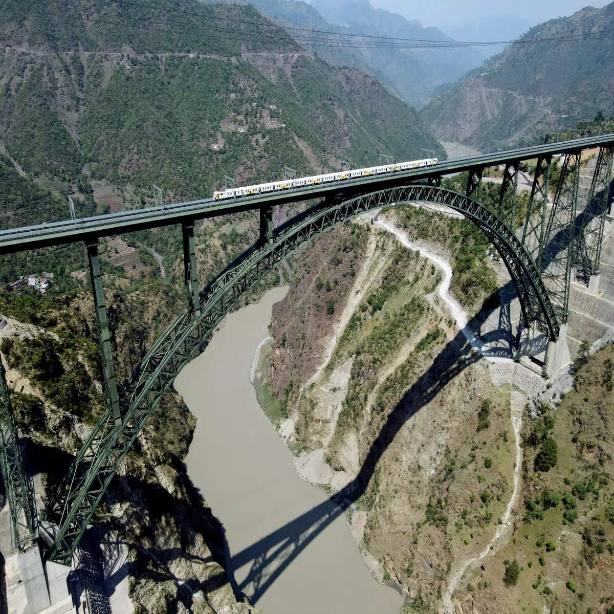
Here is a spectacular photo of a MEMU crossing the Chenab Steel Arch Bridgeon the Kashmir Rail Linki:

railway-chenab-bridge.jpg


The river is 359m (1178') below the train. The main span is a little less than half a kilometer (1532'). The total length of the bridge including approach spans is 1315m (4314').

More details can be found in Wikipedia https://en.wikipedia.org/wiki/Chenab_Rail_Bridge

More details about the geology and technical design can be found in this article: The Chenab Challenge, An Indian Engineering Marvel

One important point to note, is that the Gorge has no shear faults along it. It was created purely by erosion as the mountains rose around a river that was already in place, as is true of many river gorges in the foothills and the main Himalayan range.The highest parts of the main Himalayan Range or its foothills do not form the watershed for this reason.

The Main Thrust Fault is south of this location and is crossed by this line through the so called Tunnel 33 between Katra and Reasi, and as discussed before, this tunnel has given endless headaches during its construction.
 
Last edited:
Back
Top