East Side Access Photos

Amtrak Unlimited Discussion Forum

Help Support Amtrak Unlimited Discussion Forum:

This site may earn a commission from merchant affiliate links, including eBay, Amazon, and others.

Ryan

Court Jester
Joined
Apr 14, 2008
Messages
18,051
Location
Off looking for his sense of humor
The Atlanic's "Big Picture" feature posted some spectaular photographs of the East Side Access project underway:

http://www.theatlantic.com/infocus/2013/02/the-tunnels-of-nycs-east-side-access-project/100462/

Preview:
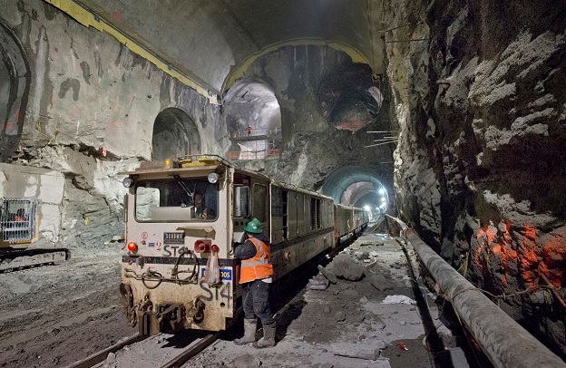
ESA_Preview.jpg
 
Dang. Wish the AU gathering had been in NYC so we could have taken a tour of this. :wub: :p
 
Last edited by a moderator:
The real problematic tunnels are not under Manhattan, but through sand in Queens under the Sunnyside Yard. That is what has caused the completion date to slip by several years.

BTW, that picture above shows the main station cavern which will contain platforms at two levels with a third level in the middle providing the entry concourse to both levels, one above and one below the entry concourse. Notice the three tubes (and a fourth hidden behind the engine) through which four tracks will enter the vault. Also notice the two tubes coming in from the side which are the entries to the concourse from the escalator and elevator banks connecting to the uppr concourse which will be at the lower level of current GCT.

Photos 4 and 8 show the location of Plaza Interlocking where the two tracks coming out from under Northern Blvd split into 4, 3 to join LIRR art Harold interlocking and one to go to the new Yard through the new Belvedere Interlocking. This last one is probably the toughest tunnel to bore.
 
Last edited by a moderator:
Wow... looking at the article and photo spread, I am truly amazed. I had no idea. Whew........

Thanks for linking.
 
The real problematic tunnels are not under Manhattan, but through sand in Queens under the Sunnyside Yard. That is what has caused the completion date to slip by several years.
BTW, that picture above shows the main station cavern which will contain platforms at two levels with a third level in the middle providing the entry concourse to both levels, one above and one below the entry concourse. Notice the three tubes (and a fourth hidden behind the engine) through which four tracks will enter the vault. Also notice the two tubes coming in from the side which are the entries to the concourse from the escalator and elevator banks connecting to the uppr concourse which will be at the lower level of current GCT.
So, if I am understanding this correct, GCT already has tracks on two levels underground (upper and lower level tracks) and this will add two more levels underneath it, so totally GCT will have tracks at four different levels underground? Wow! :eek:
 
So, if I am understanding this correct, GCT already has tracks on two levels underground (upper and lower level tracks) and this will add two more levels underneath it, so totally GCT will have tracks at four different levels underground? Wow!
That is correct.
 
Last edited by a moderator:
These are Great Pics! I agree with Betty - I'd sure like to tour the tunnels while they are under construction.

Who else sees the giant 'rock skull' in picture 13? :huh: :eek:hboy:
 
Last edited by a moderator:
So, if I am understanding this correct, GCT already has tracks on two levels underground (upper and lower level tracks) and this will add two more levels underneath it, so totally GCT will have tracks at four different levels underground? Wow!
That is correct.
And in addition, there are two levels of subway tracks in the adjacent Grand Central subway station. And the new line has to cross existing subway lines at 53rd and 60th streets. IIRC, the new line utilizes the unused lower level of the 63rd street subway tunnels (current 'F' line), built about thirty years ago?

What a maze of underground tunnels for both transit and utilities that is New York. No wonder it takes so much time and money to build things....
 
What is not visible at all in those photos is the amazing flying junction underground that connects the double tube coming in from the 63rd St Tunnel lower level into the four tubes connecting to 4 platform tracks at each level with minimal at level crossovers.

Similarly in Queens at Plaza Interlocking two tracks split into 4 with no at grade crossovers, 3 proceeding towards LI joining the current trackage at harold Interlocking and one towards Sunnyside Yard proceeding underground half way around the Sunnyside Loop (under it even as it passes under the Amtrak and LIRR Main lines, to emerge from the tunnel just to the north of the Amtrak/LIRR Main Line!

In general the GCT ESA approach tunnels are all well below any NYCTA tunnels that they pass by.
 
What is not visible at all in those photos is the amazing flying junction underground that connects the double tube coming in from the 63rd St Tunnel lower level into the four tubes connecting to 4 platform tracks at each level with minimal at level crossovers.
Similarly in Queens at Plaza Interlocking two tracks split into 4 with no at grade crossovers, 3 proceeding towards LI joining the current trackage at harold Interlocking and one towards Sunnyside Yard proceeding underground half way around the Sunnyside Loop (under it even as it passes under the Amtrak and LIRR Main lines, to emerge from the tunnel just to the north of the Amtrak/LIRR Main Line!

In general the GCT ESA approach tunnels are all well below any NYCTA tunnels that they pass by.
This shows the amount of absolutely amazing engineering that can be done when you have nice hard rock to play with (I remember reading somewhere that Manhattan is all hard rock that's easier to drill into than softer materials that pose dangers of caving in). Is there a map that shows all this maze of different railway lines under New York?
 
[SIZE=14.399999618530273px] [/SIZE]

This shows the amount of absolutely amazing engineering that can be done when you have nice hard rock to play with (I remember reading somewhere that Manhattan is all hard rock that's easier to drill into than softer materials that pose dangers of caving in). Is there a map that shows all this maze of different railway lines under New York?
I reemember reading in a John McPhee book (maybe it was "In Suspect Terrain") that the parts of Manhattan that have the tallest skyscrapers have the deepest and hardest bedrock, and other areas do not... I will look that up and see if I can give more specific info.
That is correct! When workers were building the original subways even they found changing conditions as they moved along.
 
What is not visible at all in those photos is the amazing flying junction underground that connects the double tube coming in from the 63rd St Tunnel lower level into the four tubes connecting to 4 platform tracks at each level with minimal at level crossovers.

Similarly in Queens at Plaza Interlocking two tracks split into 4 with no at grade crossovers, 3 proceeding towards LI joining the current trackage at harold Interlocking and one towards Sunnyside Yard proceeding underground half way around the Sunnyside Loop (under it even as it passes under the Amtrak and LIRR Main lines, to emerge from the tunnel just to the north of the Amtrak/LIRR Main Line!

In general the GCT ESA approach tunnels are all well below any NYCTA tunnels that they pass by.
This shows the amount of absolutely amazing engineering that can be done when you have nice hard rock to play with (I remember reading somewhere that Manhattan is all hard rock that's easier to drill into than softer materials that pose dangers of caving in).
Well Manhattan has hard rocks in the "hill" areas like Murray Hill around GCT etc, and has pretty poor crumbled rock formations in the valleys, including undreground streams that still flow through the valleys.

Queens around Sunnyside is another matter altogether. It is Glacial terminal morrain and sand, very tought tunneling-wise, and that is where the four Sunnyside tunnels are being built.

Is there a map that shows all this maze of different railway lines under New York?
Railways tunnels is only part of the story. Don;t forget the water tunnels and at shallower level the electric and steam conduits too.
 
Last edited by a moderator:
Back
Top