Matthew H Fish
Lead Service Attendant
- Joined
- May 28, 2019
- Messages
- 499
I hope we aren't getting too far into the weeds on this topic, but it is actually pretty relevant overall, because I think in lots of cities, rail terminals are in legacy locations that make them inconvenient for transit use, because of how the city has developed. So, here are some photos taken from Google Maps.

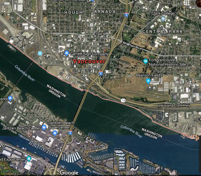
This shows the general area. The current last MAX stop is at the Portland Expo Center, towards the lower left. An extention would cross Hayden Island, probably having a stop there, and then stop in downtown Vancouver (right where it says "Vancouver" in bright red letters) and then head NE to Clark College, in the upper right of the map. It would cross I-5 either near Mill Plain, or near Fourth Plain. The Vancouver Amtrak station is just north of the river, right next to the BNSF Rail Bridge (called, poetically enough, 9.6). It is kind of visible from this map that it is in an industrial area, but not as apparent how little lies west of it.
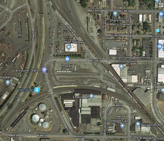
Here is a close up of the area around the station:

So here we see it located in the triangle formed by the merging of the East-West and North-South tracks (Actually, the SPS route to Spokane pretty much originates here.) The best way to get to the station is along 11st Street, which involves crossing three separate railroad tracks, on a road that doesn't have a sidewalk. This industrial area, needless to say, is not very pedestrian friendly. It is not even really motorist friendly. Across from the station, there is a gigantic industrial metal recycling plant, which is appealing, but is not really bucolic tourist fare. And there is also no transit access to the station, not without walking a few blocks.
This is one of those cases where a little bit of inconvenience can really deter travelers. A commuter rail line between Vancouver and Kelso/Longview might appeal to some people...but just added the added burden of having to walk five blocks from downtown, and it can be quite an annoyance.
Of course, all of this is due to the fact that the railroad bridge was built in 1906. At the time these rail lines were built, the area in the picture was Vancouver: the current location of I-5 would have been the eastern border of the city, other than the fort. In the years since, and especially starting in the 1970s-1990s, the city poured out eastward. So the cities current transit choices are curtailed by the legacy of Vancouver being built as a lumber town over a 100 years ago.

This shows the general area. The current last MAX stop is at the Portland Expo Center, towards the lower left. An extention would cross Hayden Island, probably having a stop there, and then stop in downtown Vancouver (right where it says "Vancouver" in bright red letters) and then head NE to Clark College, in the upper right of the map. It would cross I-5 either near Mill Plain, or near Fourth Plain. The Vancouver Amtrak station is just north of the river, right next to the BNSF Rail Bridge (called, poetically enough, 9.6). It is kind of visible from this map that it is in an industrial area, but not as apparent how little lies west of it.
Here is a close up of the area around the station:

So here we see it located in the triangle formed by the merging of the East-West and North-South tracks (Actually, the SPS route to Spokane pretty much originates here.) The best way to get to the station is along 11st Street, which involves crossing three separate railroad tracks, on a road that doesn't have a sidewalk. This industrial area, needless to say, is not very pedestrian friendly. It is not even really motorist friendly. Across from the station, there is a gigantic industrial metal recycling plant, which is appealing, but is not really bucolic tourist fare. And there is also no transit access to the station, not without walking a few blocks.
This is one of those cases where a little bit of inconvenience can really deter travelers. A commuter rail line between Vancouver and Kelso/Longview might appeal to some people...but just added the added burden of having to walk five blocks from downtown, and it can be quite an annoyance.
Of course, all of this is due to the fact that the railroad bridge was built in 1906. At the time these rail lines were built, the area in the picture was Vancouver: the current location of I-5 would have been the eastern border of the city, other than the fort. In the years since, and especially starting in the 1970s-1990s, the city poured out eastward. So the cities current transit choices are curtailed by the legacy of Vancouver being built as a lumber town over a 100 years ago.


