Sorry to be late to the party. I've been very busy of late, and haven't been checking the site enough. I think I need to have Ryan page me whenever WMATA gets a thread here.
The Largo Branch Headways
It has been mentioned before, but I wanted to try to clarify the service patterns, especially with respect to the Largo branch of the Blue Line.
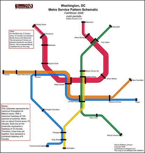
Currently the Largo branch (the "G Route") is served by 10 trains per hour (TPH) in each direction during rush hour. This means a train comes every 6 minutes in each direction. With the June service changes,
3 existing Blue Line trains per hour in each direction will become Yellow Line trains running from Franconia to Greenbelt (and Greenbelt to Franconia). This means that without any influx of new trains, the Largo branch would see a reduction to 7 TPH (8.5 min headway). So as a result, the newly added Orange Line trains will go to Largo, keeping the number of trains the same (10 TPH).
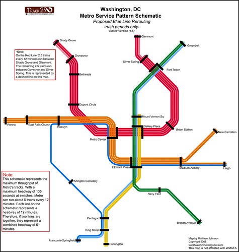
Once the Silver Line opens, some semblance of the June 2012 service pattern will need to be maintained or the terminals of the Silver and Blue lines will need to be swapped. Because unless some Silver trains continue to Largo, the G Route will see reduced headways. And in that case, it makes more sense to send
all Silver trains to Largo, and terminate
all Blue trains at Stadium/Armory, since the headways match better.
Let's look at the numbers. At any given point, a Metro track is limited to 26 trains per hour. The likely service pattern for the Blue/Orange/Silver subway is:
- 10 TPH Orange
- 10 TPH Silver
- 6 TPH Blue
With that service pattern, since both the New Carrollton and Largo branches need to have 10 TPH minimum, you'd be sending 6 TPH Blue and 4 TPH Silver to Largo, while terminating 6 TPH Silver at Stadium/Armory. That presents logistical (scheduling) problems, and make wayfinding more complicated. It just makes more sense to run all Silvers to Largo at all times and terminate all Blues at Stadium at all times.
Perhaps this graphic will also help clarify things: (left: current, right: after June 2012). Read more
here.

 Showing the Full Silver Line on the Map
First off, this means 2 different things. (1) Showing the future route of the Silver Line between K&N Junction (East Falls Church) and D&G Pocket (Stadium/Armory). (2) Showing the future route of Phase II (Reston - Ashburn).
Showing Downtown
Personally, I think that the new map should show the Silver Line running through Downtown. I have frequently encountered people who believe that the Silver Line will be
ending at East Falls Church, forcing riders to change to an Orange Line train to continue to Arlington and Downtown DC. Showing the line as under construction would help clarify that the line will indeed go downtown. However, the Metro Board decided that it might confuse riders. And they didn't want people to stand around for half an hour waiting for a train that won't be coming until 2014.
Showing Phase II
On this one, Metro should not show the second phase. At this point, it's not even clear if Phase II will get built. Loudoun County is currently threatening to pull out of the project, and Governor McDonnell and the Virginia Legislature failed to provide some of the promised state money. Until the project is a sure thing, Metro shouldn't put it on the map.
New Map Concepts
I'd also take the time to point out that the website I write for (and help run) held a
Metro map redesign contest. You can see a bunch of great takes on the redesign. Some of the ideas even made it into the final design, including the idea of splitting long station names into a primary element and a secondary element (to be shown as a subtitle).
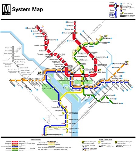
Here's the map I created for the contest:
 *Note: Above, I said I'd not put Phase II on the map, however Phase II of the Silver Line is shown on my map because it was a requirement for the contest.
Naming That Stop Between Union Station and Rhode Island Avenue
I see that Amtrak Unlimited is just a fertile ground for arguing about NoMa as everywhere else on the web. As Ryan will surely attest, shorter station names are one of my hobby horses. I want stations to have clear and concise names.
The station I generally refer to as "Florida Avenue" is a difficult station to name. First off, New York Avenue does not belong on the station name. New York Avenue stretches across the city, so that descriptor does not give a good indication of where the station is located. But moreover, the station is not located on New York Avenue, or is it even the closest station to New York Avenue. Mount Vernon Square and Metro Center are
both closer (walking distance) to New York Avenue than the station in question.
Florida Avenue is not ideal either. Florida Avenue also stretches across the city, and the station could be anywhere along that line.
Personally, I favor neighborhood names in general when it comes to naming transit stations. "Columbia Heights" is superior to "Georgia Avenue" (especially since 4 stations are under Georgia Avenue). "Brookland" is better than "Rhode Island Avenue".
The real issue with the station that we're discussing here (which I am trying not to actually name) is that the place it is located does not really have a historic neighborhood name. It was largely rail yards and industrial buildings. Some have suggested resurrecting a historic name that referred to a nearby area which has fallen into disuse, "Swampoodle".
So the real question is, what do you do when there aren't any good streets to name the station after and there's no defined neighborhood name?
Well, the answer is that you pick the best one you can. NoMa is brand that many recognize. The BID has been around for over a decade. Just because some people are unfamiliar with the name does not make it unacceptable.
I've found that many people in the region know neighborhoods simply because they have Metro station names. For example, most people I talk to know of Petworth and Columbia Heights (both on the Metro map). Not as many people are familiar with Park View, which
is on the Metro system, but which does not have its name appended to a station. If there was a Metro station in 14th Street Heights, it might be as recognized a neighborhood as Cleveland Park.
Putting NoMa on the Metro map will make it a recognized name within a few years. And people will know where it is because it's
on a map. Most tourists have no idea where anything is, anyway. Locals either know it or they don't, and if they don't, they'll learn it (except for the geographically challenged, who wouldn't be able to find it, no matter what you called it).
There's a lot of sturm and drang about NoMa being on the Metro map, and if you have a better suggestion, feel free to suggest it. But don't just object because it's "contrived". After all, every place name on the planet is contrived. Some have just been around longer than others.
Characters Matter Less than Concepts
Some have suggested that we could shorten the station name by just writing it as NY Av/FL Av/GU.
Unfortunately, that station name is the same length. Characters don't matter, since the stop is not going to be announced as "N-Y Av, F-L, Av, G-U." It will be announced as "New York Avenue, Florida Avenue, Galluadet University." It's the number of concepts in the station name that really matter, rather than the number of characters.
Imagine you're a tourist and you hear this announcement over the loudspeaker:
"Due to scheduled trackwork, we're currently experiencing delays between Dunn Loring Merrifield and West Falls Church Virginia Tech University of Virginia."
If you don't know the system, is that a list of 5 stations or 2? Or 4? And isn't it odd that Blacksburg and Charlottesville are on the same line? I had no idea that the Metro went that far.
As far as I'm concerned, "King Street" = "King St.", "U Street" = "U St", and "Rhode Island Avenue" = "R.I. Av"


